Establishing a property boundary: where is the line, and who decides?
Sources checked on 30 August 2026
The cadastral map shows roughly where the boundary runs, with a deviation of about ten centimetres. A field sketch or a boundary reconstruction by the Kadaster makes it visible on the ground. If you and your neighbours cannot agree, the court decides where the boundary lies under article 5:47 of the Dutch Civil Code. A Kadaster measurement is evidence, not a binding ruling.
Rather have it done?
Post your job for free. Gardeners near you respond with their own price and you choose. Your money stays safe until you approve the work.
Which route do you need
Three questions take you to the right route, and in practice they save you hundreds of euros. Do you only want to know roughly where the line runs, or does it have to be visible on the ground? Is there an actual disagreement with your neighbours, or do you simply want certainty before you build? And is something of your neighbours' already standing across the line, and if so, for how long?
If you only want to know, the cadastral map is enough. If you are about to build and want certainty without a row, the field sketch is the cheapest serious step. If there is a real dispute you need a boundary reconstruction, and possibly the court after that. If something of your neighbours' has stood on your land for years, read the section on prescription further down first, because a time limit applies there.
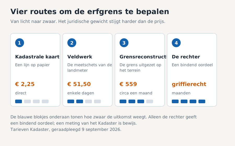
The table below puts the four routes side by side. Pay particular attention to the last column: what a route is worth legally varies far more than what it costs.
The four routes side by side
This is the overview that appears on no other page. The amounts are the Kadaster's private-customer rates, consulted on 9 September 2026; they can change, so check them on kadaster.nl before ordering.
| Route | What you get | Cost | Lead time | Legal weight |
|---|---|---|---|---|
| Cadastral map | The boundary as a line on a map | € 2.25 digital | Immediate | Administrative line, not proof of the legal boundary |
| Request the field sketch | The surveyor's original measurement sketch | € 51.50 | A few days | Evidence, but you have to be able to read it |
| Boundary reconstruction | The boundary staked out on site, with a report | € 559 up to 500 metres | About a month | Strongest evidence short of court |
| The court | A ruling on where the boundary lies | Court fee and lawyer | Months | Binding, this is the end of the line |
Route 1: look at the cadastral map yourself
The cadastral map is the starting point and it is almost free. You see the plot boundaries as lines, with the plot number alongside. For a first impression that is enough: you can see whether that fence is roughly right or metres out.
Just do not build a fence on it. The cadastral boundary is an administrative line drawn from earlier measurements, and the deviation from the actual boundary is around ten centimetres. In a narrow city garden or on a shared driveway that is exactly the difference people fall out over.
More importantly, the cadastral boundary is not automatically the legal boundary. What the deed of transfer says, and what has actually been happening for years, can carry more weight. The map tells you where to look, not who owns what.
Route 2: request the field sketch for 51.50 euros
This is the step almost nobody knows about, and for most people it settles the matter. A field sketch is the original measurement drawing the surveyor made when the boundary was recorded, also called the record of findings. It shows the measurements used at the time, taken for example from the corner of a house.
It costs 51.50 euros, and the Kadaster tells you in advance whether the sketch is usable in your case. If you then decide against it, you pay nothing. That makes this a near risk-free first step.
Sometimes it yields nothing. That happens when no buildings are registered on your plot to measure from, when the boundary was recorded only in coordinates, or when there is too little dimensioning on the sketch. The Kadaster allows you to measure yourself with a field sketch in hand, but says plainly that this requires surveying knowledge: the sketch is not to scale and you have to work out the distances from the measurement figures yourself.
Route 3: have a boundary reconstruction carried out
In a boundary reconstruction a Kadaster surveyor comes out and stakes the boundary on the ground. This is the strongest evidence you can obtain without going to court, and it is the route you take when there is a genuine dispute or when something expensive is about to be built.
It runs in fixed steps with their own deadlines: you receive a quotation within five working days, after approval the surveyor contacts you within five days, the fieldwork is scheduled within twenty days, and the report follows within four weeks of the measurement. In practice you are about a month down the line. The measuring itself usually takes two to three days.
You receive a report with the measurement sketch, a file of coordinates and a delivery confirmation. The price runs in bands of five hundred metres of boundary: 559 euros up to 500 metres, 1,118 up to 1,000 metres, 1,677 up to 1,500 metres and 2,236 up to 2,000 metres.
One thing to know beforehand, and the Kadaster says so itself: the reconstructed boundary reflects the boundary as originally indicated. It is evidence, not a binding ruling. If the neighbours still disagree, only the court decides.
Route 4: the court determines the boundary
Here the law is on your side, and this article appears on almost no other page about this subject. Article 5:47 paragraph 1 of the Dutch Civil Code states that where the course of the boundary between two plots is uncertain, either owner may at any time apply to the court to determine the boundary. At any time means without a time limit.
There is a second paragraph that can work in your favour. Where the boundary is uncertain, the ordinary legal presumption that whoever possesses something owns it does not apply. Your neighbour therefore cannot rely on the argument that he has been using that strip already.
The court has latitude in what it decides. Under the third paragraph it may divide the uncertain area into equal or unequal parts, or award it in its entirety to one of the parties, possibly with compensation. So there is no automatic line down the middle.
This route only comes into play when neither party can prove where the boundary lies. If you can establish the course of the boundary with a field sketch or a reconstruction, article 5:47 does not apply and it simply comes down to your evidence.
The neighbours will not cooperate
Before you go to court there is a step that is almost never mentioned: demanding boundary markers. Article 5:46 of the Dutch Civil Code gives you the right to require the owner of the adjoining plot to have clearly visible boundary markers placed on the line, or existing ones renewed. This too can be done at any time.
That is a separate claim and a lighter one than proceedings about the boundary itself. You are not asking who is right, you are asking for the boundary to be made visible. In many cases that is exactly what resolves the conflict.
Put it in writing first. Describe where you believe the boundary runs and on what you base that, ask them to place markers together within a reasonable period, and say that you will otherwise involve the Kadaster. A dated message is your later evidence that you tried. If that leads nowhere, most Dutch municipalities offer free neighbourhood mediation.
Your neighbour says the land is his now
If someone possesses a strip of land for long enough, it can indeed become their property. Where possession is in good faith that takes ten years, under article 3:99 of the Dutch Civil Code. Without good faith it takes twenty years, through article 3:105 combined with 3:306 and 3:314 paragraph 2.
What matters is whether the possession was unequivocal and outwardly recognisable. So: was there a fence, was the strip laid out as garden, was it maintained? Whether the original owner knew about it is not required for the period to be completed.
And then comes the part you will not read elsewhere. If you lost land to someone who possessed it in bad faith, that need not be the end. On 24 February 2017, in the Heusden case, the Dutch Supreme Court held that the former owner can bring a claim in tort against the new owner and seek compensation in kind under article 6:103 of the Civil Code. Compensation in kind here means handing the land back.
That claim does run against a clock. Under article 3:310 paragraph 1 a claim for compensation lapses five years after the day on which you became aware both of the loss and of the person responsible. If you discover you have lost land, send a written notice of liability straight away. Such a notice interrupts the period while you work out where you stand.
What may stand on and along the boundary
Once the boundary is clear the next question follows: what may stand there. A fence behind the front building line may generally be two metres high without a permit; on the street side it is one metre. Your municipality's environment plan may be stricter, so always check it.
For planting, article 5:42 sets hard distances: no trees within two metres of the boundary line and no shrubs or hedges within half a metre, measured from the centre of the base, unless your neighbour consents. If branches overhang, you may only remove them yourself after a formal request; roots you may cut back straight away.
If you live in a built-up part of a municipality, article 5:49 paragraph 1 lets you require your neighbours to cooperate in a two-metre dividing wall on the boundary. That too can be demanded at any time.
Who pays for the measurement
The main rule is simple: whoever orders the measurement from the Kadaster gets the bill. That applies to the field sketch and to the boundary reconstruction. Your neighbours are not obliged to contribute to a measurement you order, even if the outcome proves you right.
That is a reason to agree it beforehand. Propose splitting the cost and accepting the outcome in advance, whatever it turns out to be. In the worst case that costs you half of 559 euros and it saves you proceedings.
For a dividing wall in a built-up area the cost split is governed separately by article 5:49. Take legal advice on that before you start building, because the division depends on the situation.
What you can do today
Start with the cadastral map and see whether the difference is big enough to act on. If it comes down to centimetres you are within the measurement uncertainty, and an expensive survey is rarely worth it.
Then request the field sketch. You hear in advance whether it is usable and you pay nothing if you decide against it, so this is the cheapest way to make progress.
Put your position to your neighbours in writing, with the date on it, even while relations are still good. Not as a threat, but because it is the only thing you can produce later.
If you think something of your neighbours' has stood on your land for years, do not wait. Send a written notice of liability to keep the five-year period open, and work out the details afterwards.
Once the boundary is settled and a fence, paving or partition has to be built, you can post the job free of charge on JouwPro and compare the responses side by side.
Done reading?
Describe the job in two minutes. Gardeners respond with their price, you compare and choose. Free, with no strings attached.
Post your job for freeFrequently asked questions
What does it cost to have a property boundary determined?
The cadastral map costs 2.25 euros digitally. The field sketch, the surveyor's original measurement drawing, costs 51.50 euros and you pay nothing if you decide against it after the check. A boundary reconstruction, where the line is staked out on site, starts at 559 euros for up to five hundred metres of boundary. Kadaster rates, consulted on 9 September 2026.
Is the cadastral boundary the same as the legal boundary?
No. The cadastral map is an administrative representation with a deviation of about ten centimetres from the actual boundary. What the deed of transfer says, and how the plot has in fact been used for years, can carry more weight. Where there is disagreement the court decides, not the map.
How long does a boundary reconstruction take?
About a month. The Kadaster sends a quotation within five working days, after approval the surveyor contacts you within five days, the fieldwork is scheduled within twenty days and the report follows within four weeks of the measurement. The measuring itself usually takes two to three days.
Can my neighbour acquire part of my land through prescription?
That is possible. After ten years of possession in good faith under article 3:99 of the Dutch Civil Code, and after twenty years without good faith through article 3:105 combined with 3:306 and 3:314 paragraph 2. The possession must have been unequivocal and outwardly recognisable. Whether you knew about it is not required for the period to be completed.
Can I recover land lost through prescription?
If the other party possessed it in bad faith, that possibility exists. On 24 February 2017, in the Heusden case, the Dutch Supreme Court held that you can bring a claim in tort against the new owner and seek compensation in kind, which amounts to handing the land back. That claim lapses five years after you became aware of the loss and of the person responsible.
What can I do if my neighbours will not cooperate?
You can demand boundary markers. Article 5:46 of the Dutch Civil Code gives you the right to require clearly visible markers to be placed on the boundary, and that can be done at any time. If it remains unclear where the line runs, article 5:47 lets you ask the court to determine it. Neighbourhood mediation is free in most municipalities and comes first.
Sources
Every claim on this page comes from one of these sources. They were checked on 30 August 2026. Legislation changes, so check the source itself if anything matters to you.
Tools for your own address
Three things you can check here for free that you will not find like this anywhere else. They run on open data from the Dutch Land Registry, the buildings register and the national energy agency, so the answer applies to your house and not to an average.
This is not legal advice
We set out what the rules say and where they are. Your situation may differ, and in a dispute your own contract, your deed of division or your local council's bylaw takes precedence. If you cannot work it out, Het Juridisch Loket, the Huurcommissie or a lawyer can help.